Deleted
Deleted Member
Posts: 0
|
Post by Deleted on Oct 6, 2012 3:29:58 GMT
|
|
Deleted
Deleted Member
Posts: 0
|
Post by Deleted on Oct 6, 2012 7:50:51 GMT
|
|
Deleted
Deleted Member
Posts: 0
|
Post by Deleted on Oct 7, 2012 4:25:53 GMT
|
|
Deleted
Deleted Member
Posts: 0
|
Post by Deleted on Oct 7, 2012 4:28:22 GMT
|
|
Deleted
Deleted Member
Posts: 0
|
Post by Deleted on Oct 7, 2012 4:29:02 GMT
|
|
Deleted
Deleted Member
Posts: 0
|
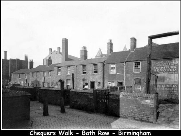
Post by Deleted on Oct 7, 2012 4:33:27 GMT
Back of 131 Fazeley Street Birmingham.Attachments:
|
|
Deleted
Deleted Member
Posts: 0
|
Post by Deleted on Oct 7, 2012 4:55:56 GMT
|
|
Deleted
Deleted Member
Posts: 0
|
Post by Deleted on Oct 7, 2012 4:56:44 GMT
|
|
Deleted
Deleted Member
Posts: 0
|
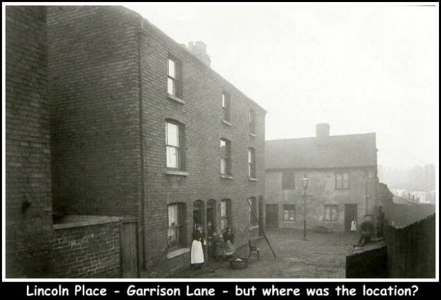
Post by Deleted on Oct 7, 2012 4:59:00 GMT
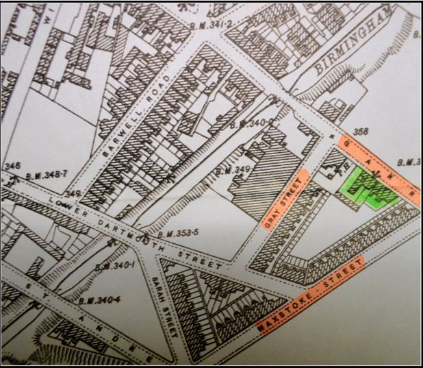
Lincoln Place - Garrison Lane, but where was the location?Attachments:
|
|
Deleted
Deleted Member
Posts: 0
|
Post by Deleted on Oct 7, 2012 4:59:48 GMT
|
|
|
|
Post by Jerry on Oct 7, 2012 7:00:58 GMT
Lincoln Place - Garrison Lane, but where was the location? Hi Ray Lincoln Place was between Gray Street and Maxstoke Street. It's all part of Bordesley Village now Jerry |
|
Deleted
Deleted Member
Posts: 0
|
Post by Deleted on Oct 7, 2012 9:36:50 GMT
Hi Jerry & Thanks for the location.Perhaps you could further help this thicko with these two questions:
1 - Was the pub on the corner of Gray Street always called the Sportsman?
2 - What does the 'arrow' pointing to the buildings marked on green {Lincoln Place} identify?
CLICK THE PICTURE TO ENLARGE [/size] Many thanks,
Ray. [/color] [/size] |
|
|
|
Post by bernie120g on Oct 7, 2012 9:54:59 GMT
Hi Ray can,t help with the pub but I have read that a cross above a building means there is an entry or entrance below not sure if that is a cross though
|
|
|
|
Post by Jerry on Oct 7, 2012 10:37:18 GMT
Hi Jerry & Thanks for the location.Perhaps you could further help this thicko with these two questions:
1 - Was the pub on the corner of Gray Street always called the Sportsman?
2 - What does the 'arrow' pointing to the buildings marked on green {Lincoln Place} identify?
CLICK THE PICTURE TO ENLARGE [/size] Many thanks,
Ray. [/color] [/size] [/quote] Hi Ray The Sportsman, like a lot of pubs, started life as a "beer retailer" It's listed as such as far back as 1892, which is as far back as I can check. It became The Sportsman some time between 1915 and 1940. Sorry I can't pin it down any closer than that Jerry |
|
|
|
Post by planetmalc on Oct 7, 2012 12:03:02 GMT
Hi Jerry & Thanks for the location.Perhaps you could further help this thicko with these two questions:
1 - Was the pub on the corner of Gray Street always called the Sportsman?
2 - What does the 'arrow' pointing to the buildings marked on green {Lincoln Place} identify?
CLICK THE PICTURE TO ENLARGE [/size] Many thanks,
Ray. [/color] [/size] [/quote] Those arrows are all over the Godfrey edition maps, Ray, and they may point to the spot from which a height-above-sea-level value has been measured (don't ask me how!). Such values will be preceded by the letters 'B. M.', which stands for 'bench mark', but I've no idea if any physical indicator was left at these locations (like toned-down trig points). There are other height values marked on the maps (without the BM prefix) and these might represent values that have been DERIVED via comparison with other nearby BM values, rather than having been actually measued against sea level (but this is just a guess on my part). If only we could buy maps like this today.  |
|